
 |
| Reykjavik Skyline |


We agreed to celebrate our 11th Anniversary a little late with a mid-April, 3-night excursion. We flew nonstop, Seattle to Reykjavik, a 6.5 hour flight (red-eye). We stayed in the company hotel, rode on the company shuttles from/to the airport, and took the company tours. (In Iceland, ‘the company’ is Iceland Air, of course.)
 |
| Church at Vík |
It is roughly an hour from the international airport (Keflavik) to Reykjavik. During that time, you cross a perfectly flat lava field with nothing there. I wondered why the airport needed to be so far away. Turns out, the Allies had an air base at Keflavik during WWII, so it was most cost efficient to modernize it rather than to build a new one. (Also, the company runs the buses to and fro.)
Iceland has a population of ~320,000 of which over 200,000 live in the Reykjavik area. Food and clothing are expensive. Other than a few small gifts, we decided against buying anything there.
As seen in the photos here, we experienced great weather. Icelandic weather is noted most of all for its sudden changeability. We received a small amount of drizzle and one short episode of significant sleet at a glacial site. Otherwise it was dry and somewhat sunny.
There is a joke that Iceland is green and Greenland is ice. The joke may resonate in summer, but in spring, Iceland is brown. Iceland is only ~300 km from Greenland.
The first day we stayed awake by exploring Reykjavik by city bus and walking. (We received a city bus pass from the company.) Staying awake was supposed to keep us from becoming disabled by jet lag (desynchronosis). But we felt somewhat sleep deprived the first two days, finally getting back toward normal just before getting on the homeward flight. (Age and short stay are not conducive to recovery from desynchronosis.)
The bus picked us up across the road from our hotel. We got off a couple of stops later at Reykjavik’s main landmark, Hallgrimskirkja. This church (micro-cathedral) was designed in 1937, employing motifs to resemble basalt lava flow features familiar in Iceland. Construction spanned 1945-1986 (short summers?). Aside from hosting services for the Church of Iceland (Lutheran), it also houses a mechanical-action, 5275-pipe organ.
 |
| Hallgrimskirkja |
 |
| Hallgrimskirkja |
 |
| Nave Looking Toward Chancel |
 |
| Chancel |
 |
| Organ Console |

The church also serves as a 73 meter tall observation tower, providing panoramic views of the city, harbor, and mountains beyond.


 |
| View With Tjornin Pond |

Þingvellir exhibits the rifting process occurring between the North American and Eurasian tectonic plates under Iceland, an extension of the mid-Atlantic rift zone that has been separating since Africa and South America were joined in Pangaea. The Þingvellir valley floor gradually sinks as the sides pull apart. The fault scarp of Almannagjá on the western edge is shown here with the valley beyond. The valley is home to Lake Þingvallavatn and the Öxará River.


The pictures above remind me of a joke told by the tour guide:
'What do you do if you get lost in an Icelandic forest? Stand up!'
The farther north one goes, the less tall the vegetation. Taken to the extreme, Barry Lopez explains in Arctic Dreams that in the tundra and further north places, one necessarily stands on top of the local 'forest'. The picture below perhaps shows such a vista, a forest of lichen.

In Iceland's outback, any structure attracts the eye and camera, particularly if it sports a colorful roof.

One walks through an area of obvious geothermal activity - mudpots, fumaroles, hot springs - to get to the geysers.

The star attraction, Geysir, became merely an occasional player a few years ago, but nearby Strokkur still delivers the goods every few minutes. Here, Strokkur is shown at rest, then forming its blue bubble, which suddenly erupts into its full height display.


Other geysers are nearby, including the former king, Geysir, and its sidekick, Litl Geysir.


 |
| Litl Geysir |
Continuing on by bus, we came to the Gullfoss.


Along the route back to Reykjavik, I took my least blurry picture of Icelandic horses. No other breeds of horse are permitted in Iceland. We saw them everywhere, but never in use, just grazing. They are a rare five-gaited horse, sure-footed and robust due to an Arctic-worthy winter coat.

On day three, the second tour took us to the south coastal plain, down to the black volcanic beach at Vík í Mýrdal and back. This tour travels a small part of Route 1, the Ring Route or Hringvegur that circles the island near the coast for 1332 km. Along the way, we saw Sólheimajökull glacier (outlet glacier for the Mýrdalsjökull ice cap), interesting lava formations, more countryside through bus windows, more waterfalls, and a folk museum.


 |
| Reynisdrangar Sea Stacks |
The town of Vík í Mýrdal lies just downslope from the Mýrdalsjökull ice cap, which sits atop the Katla volcano (overdue for activity). Its next eruption may be expected to melt a portion of the ice cap, resulting in floods with potential to wash away the entire town except for the church sitting high on a hill. The church is a designated evacuation center for the town.
Vík is the wettest area of Iceland (3x wetter than Reykjavik), with the Mýrdalsjökull ice cap receiving nearly 50 meters of snow annually.


Going south from Vík, the next land mass encountered is Antarctica. The open ocean generates large rollers that land with force on this beach.

All over the parts of Iceland we visited, a grass with a limp growth habit akin to coarse hair covers everything. It seems to be an Arctic fescue, here still dormant in early spring.

Toward the end of our tour, we visited the Skogar Folk Museum. The rural Icelandic living standards up until WWII were typically medieval. Small turf-covered structures housed the farmers in cramped conditions during the long winters. Their family time may have involved singing rimur, long song sagas of gods and heroes past.
The shortest days have only about 3.5 hours of daylight. The summer days are very long to compensate. Here the houses are in their winter brown. In the summer, the turf, which is living, will be bright green.
One sees extensive use of wood on the interiors of these houses, but lumber-grade wood does not grow naturally in Iceland. In earlier times, driftwood was a local source of wood for building and crafts.


Near the museum is the Skógafoss, the falls on the Skóga river where the river flows over the former seacoast cliffs.

Next up on the return itinerary was a house/barn imbedded below a lava outcrop next to the highway.


Behind the farm below, the Eyjafjallajökull can be seen faintly atop the mountains. This ice cap sits atop a 1651m stratovolcano, which erupted in April-May 2010, bringing air transport to a stop over northwest Europe for several days.
This farm survived the eruption and appears to be an example of modern, mechanized agriculture. Further toward the city, there are large greenhouses that are lighted and heated. Iceland must import large quantities of fresh produce, but due to the abundant geothermal energy supply used for heating and electricity, they are also able to grow their own despite the short outdoor growing season.

The trip would not be complete without yet another foss, this time Seljalandsfoss. There is a shallow cave behind the falls for an insider's view.


On our third evening, we got a tip from another couple and went to a cafe specializing in fish and chips. It was our best meal in Iceland, and also perhaps the least expensive.
On the last morning, I walked to Tjornin Pond to see what water birds were there. The pond is in a small park near the city center, surrounded by a nice residential district. Some views from the church tower, beginning this post, look down on the pond.


I found four species of bird that I had never photographed before, so I added them to my collection.
 |
| Common Eider Duck |
 |
| Greylag Goose |
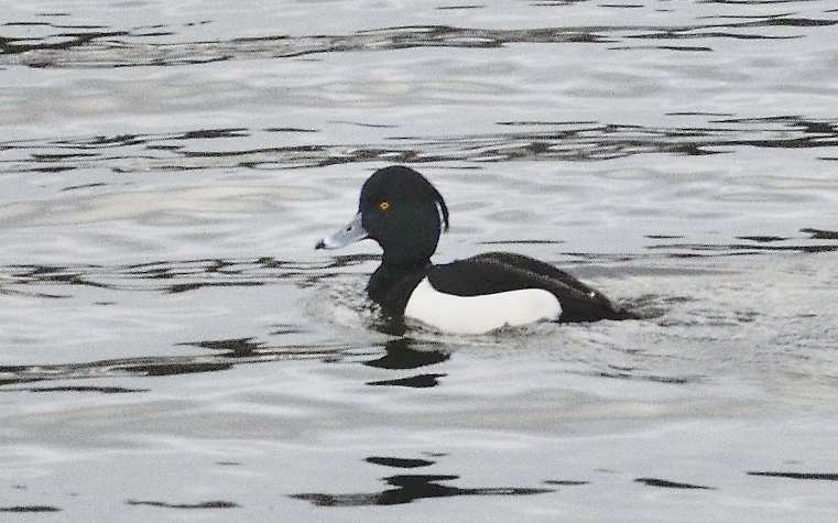 |
| Tufted Duck |
 |
| Whooper Swan |
We were too early by a few weeks to see the puffins around Vík, so we may need to return. More importantly, the company-guided tours offered little in way of understanding of the people and culture of Iceland, even more reason to return and dig deeper.
No comments:
Post a Comment